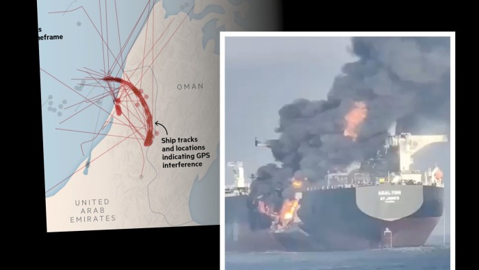
On the night of June 15 an oil tanker near the Strait of Hormuz, the Liberian-flagged Front Eagle, transmitted several impossible positioning signals, repeatedly appearing to jump dozens of miles in an instant.
Early the following morning, it collided with another tanker, which burst into flames.
The cause of the crash remains unclear, but the Front Eagle’s apparent bizarre movements near the Iran-controlled strait were, experts agree, a sign of global positioning system interference, a tool of modern warfare that sharply increases the risk of accidents.
The Front Eagle was not the only vessel affected by the interference, which began after Israel attacked Iran last week. Ship and aircraft tracking data has shown hundreds of vessels appearing to travel over land or turn in circles en masse in the seas around the strait.
The Joint Maritime Information Center, a multinational initiative to provide advice to ships in the Middle East, said the “extreme” interference stemmed from the Iranian port of Bandar Abbas and recommended ships navigate with radar or visuals.
The UK Maritime Trade Operations said it had received multiple reports of interference with navigation signals in the Gulf, warning it was having a “significant impact” on vessels.
Ollie Ballinger, a researcher at University College London who studies geolocation of ships, said: “Ships showing up at airports, going in perfect circles, having hundreds of ships superimposed directly on top of each other [and] showing up on land are all tell-tale signs” of navigation interference.
A Financial Times analysis of ships’ reported locations show at least 170 were affected by interference during a single two-hour window on Tuesday morning.
Since Israel launched its large-scale offensive against Iranian targets last week, energy analysts have raised concerns the conflict could affect traffic through the strait, through which about one-third of the world’s seaborne oil supplies travel each day.
The Front Eagle is owned by Frontline, the world’s largest publicly listed oil tanker company. Frontline’s chief executive told the FT on Friday that it would no longer accept new contracts to enter the Gulf through the Strait of Hormuz because of the increased risks.
Iran’s regime has historically threatened to block the Strait of Hormuz in the event the country is attacked, but does not appear to have taken action beyond the alleged jamming.
Tehran targeted vessels in the strait during the Iran-Iraq war in the 1980s and more recently was accused of attacks on tankers near the strait in 2019. It has never been able to completely block traffic.
Following the collision on Monday, the United Arab Emirates coastguard rescued 24 people from the Front Eagle, while Frontline said its crew was unharmed and the “navigational incident” was unrelated to the “current regional conflict”.
A spokesperson for Frontline said “there is nothing to suggest any outside interference” led to the collision.
GPS jamming is carried out by transmitting a strong radio signal that blocks signals sent to and from satellites by global navigation satellite systems. Alternatively, so-called “spoofers” mimic genuine signals but are misleading.
Experts including Sal Mercogliano, a maritime historian at Campbell University in North Carolina and a former merchant mariner, said it was possible GPS interference played a role in the crash, especially given the Front Eagle turned at the last moment towards the ship it then collided with, a crude oil tanker called Adalynn.
GPS interference could have affected the ship’s autopilot navigation, Mercogliano suggested.
“Somebody’s playing with GPS and AIS in the area and ships really cannot rely on their GPS,” he said, referring to automatic identification system, which is a GPS-based ship tracking system.
Todd Humphreys, an expert in GPS interference at the University of Texas at Austin, said: “In a tight strait like Hormuz, it only takes a slight nudge of GPS to push ships dangerously off course. Nonetheless, radar and visual lookout should have prevented this crash even if one or both ships were spoofed.”
Bridget Diakun, an analyst at shipping data provider Lloyd’s List, said it was possible navigation systems “don’t really return to normal” after being spoofed or jammed, and can continue to show false data, adding to the risk of accidents.
GPS interference has become a widespread tactic in modern conflicts, with hotspots including Ukraine, the Baltics, Israel and the India-Pakistan border, though it is often difficult to track the precise origin of a jamming episode.
Thomas Withington, an expert in electronic warfare at the Royal United Services Institute, said the interference in the Strait of Hormuz was likely down to Iran, which probably aimed to protect its facilities and infrastructure from attacks and surveillance by drones and guided missiles.
But the signals involved are so powerful that civilian GPS receivers in ships, aircraft and even mobile phones are “invariably” being caught, Withington added.
“It’s a very irresponsible thing to do . . . that’s how accidents are going to happen. If people are relying on GNSS alone for navigation, and that service is either being jammed or it’s conveying false information, then the situation becomes quite dangerous.”
Additional reporting by Chris Cook
Read the full article here